Log in
All resources
Create a design
887 Free Artworks of Old Maps Of France
bibliothèque nationale de france
marco boschini
maps of the islands of greece by marco boschini (1658)
chorographia britanniae (1741-1742)
maps of ports and fortresses of the mediterranean by marco boschini (1651)
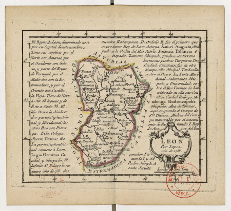
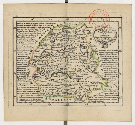
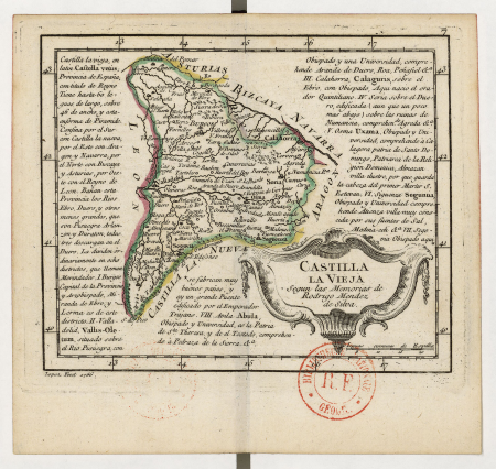
atlas geographico del reyno de españa e islas adjacentes (1757)
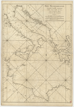
carte de la mer méditerranée en trois feuilles (dheulland et al.)
old maps of the central mediterranean
maps by willem and johannes blaeu
maps by alexis-hubert jaillot
atlas geographico del reyno de españa e islas adjacentes (1757)
old maps of castile and león
carte de la mer méditerranée en trois feuilles (dheulland et al.)
old maps of the central mediterranean
carte de la mer méditerranée en trois feuilles (dheulland et al.)
old maps of the central mediterranean
maps of the greek colonies
old maps of ancient greece
maps of the islands of greece by marco boschini (1658)
old maps of psarà
maps of paris from the david rumsey historical map collection
1778 in paris
chorographia britanniae (1741-1742)
18th-century maps of staffordshire
chorographia britanniae (1741-1742)
18th-century maps of hampshire
chorographia britanniae (1741-1742)
18th-century maps of hertfordshire
maps and topographical views by joris hoefnagel
1580s maps of spain
maps of rodrigues island
old maps of mauritius
chorographia britanniae (1741-1742)
18th-century maps of surrey
chorographia britanniae (1741-1742)
18th-century maps of leicestershire
chorographia britanniae (1741-1742)
18th-century maps of devon
maps of the islands of greece by marco boschini (1658)
old maps of samos
maps of ancient italy by philipp clüver
old maps of marche
maps of the islands of greece by marco boschini (1658)
old maps of rhodes
chorographia britanniae (1741-1742)
18th-century maps of cheshire
chorographia britanniae (1741-1742)
18th-century maps of worcestershire
chorographia britanniae (1741-1742)
18th-century maps of warwickshire
chorographia britanniae (1741-1742)
18th-century maps of suffolk
chorographia britanniae (1741-1742)
18th-century maps of shropshire
18th-century maps of herefordshire
old county maps of herefordshire
18th-century maps of norfolk, england
chorographia britanniae (1741-1742)
chorographia britanniae (1741-1742)
18th-century maps of rutland
chorographia britanniae (1741-1742)
18th-century maps of bedfordshire
chorographia britanniae (1741-1742)
18th-century maps of derbyshire
maps of the islands of greece by marco boschini (1658)
old maps of kea (cyclades)
maps of the islands of greece by marco boschini (1658)
old maps of kalogeros islets
maps of the islands of greece by marco boschini (1658)
old maps of delos
old maps of the rhineland
maps by gerard de jode
chorographia britanniae (1741-1742)
old county maps of county durham
chorographia britanniae (1741-1742)
18th-century maps of yorkshire
chorographia britanniae (1741-1742)
18th-century maps of lincolnshire
18th-century maps of buckinghamshire
chorographia britanniae (1741-1742)
18th-century maps of northamptonshire
chorographia britanniae (1741-1742)
chorographia britanniae (1741-1742)
18th-century maps of dorset
chorographia britanniae (1741-1742)
18th-century maps of somerset
chorographia britanniae (1741-1742)
18th-century maps of berkshire
old maps of whole wales (alone)
1670s maps of wales
18th-century maps of gloucestershire
chorographia britanniae (1741-1742)
francesco nicolini
old maps of ikaria
maps of provence by pierre-jean de bompar
bibliothèque nationale de france
old maps of the republic of genoa
maps by alexis-hubert jaillot
old maps of the republic of genoa
maps by alexis-hubert jaillot
atlas geographico del reyno de españa e islas adjacentes (1757)
old maps of castilla la nueva
atlas geographico del reyno de españa e islas adjacentes (1757)
old maps of castilla la vieja
maps of the islands of greece by marco boschini (1658)
old maps of the sporades
maps of ports and fortresses of the mediterranean by marco boschini (1651)
old maps of heraklion
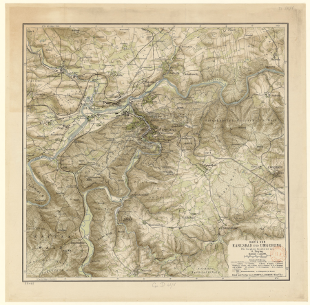
gustav freytag (cartographer)
old maps of karlovy vary
maps of ports and fortresses of the mediterranean by marco boschini (1651)
old maps of kythira
maps of the islands of greece by marco boschini (1658)
old maps of kinaros and levitha
carte de la mer méditerranée en trois feuilles (dheulland et al.)
old maps of the central mediterranean
old maps of seville
baroque
16th-century maps of crete
old maps of candia
baptista van doetecum
jacques surhon
18th-century maps of morocco
1700s maps of algeria
chorographia britanniae (1741-1742)
18th-century maps of wiltshire
old maps of leiden
views of leiden
géographie générale; physique, politique et économique (1876)
old maps of the pyrenees
plan de paris d'ambroise tardieu - 1839
bibliothèque nationale de france
maps of the islands of greece by marco boschini (1658)
old maps of mykonos
maps of the islands of greece by marco boschini (1658)
old maps of leros
maps of the islands of greece by marco boschini (1658)
old maps of ios
maps of the islands of greece by marco boschini (1658)
old maps of patmos
maps of the islands of greece by marco boschini (1658)
old maps of naxos
maps of the islands of greece by marco boschini (1658)
old maps of kythnos
maps of the islands of greece by marco boschini (1658)
old maps of kos
maps of the islands of greece by marco boschini (1658)
old maps of nisyros
maps of the islands of greece by marco boschini (1658)
old maps of amorgos
maps of the islands of greece by marco boschini (1658)
old maps of tilos
maps by jean-baptiste bourguignon d'anville
old maps of roman hispania
old maps of europe
achille belloguet
maps by willem and johannes blaeu
old maps of capitanata
maps of the islands of greece by marco boschini (1658)
old maps of anafi
maps of the islands of greece by marco boschini (1658)
old maps of kalymnos
maps of the islands of greece by marco boschini (1658)
old maps of andros
maps of the islands of greece by marco boschini (1658)
old maps of alonissos
16th-century maps of crete
old maps of candia
old maps of europe
achille belloguet
old maps of the kingdom of naples
1700s maps of italy
historical photographs of seine-saint-denis
postcards of pantin
atlas minor gerardi mercatoris (1609)
maps of europe by mercator-hondius
old maps of the strait of gibraltar
hendrik de leth
maps of ports and fortresses of the mediterranean by marco boschini (1651)
old maps of souda (crete)
old maps of nova belgica et anglia nova
maps by willem and johannes blaeu
maps of the islands of greece by marco boschini (1658)
old maps of athos
maps of the islands of greece by marco boschini (1658)
old maps of santorini
maps of the islands of greece by marco boschini (1658)
old maps of chalki
maps of ports and fortresses of the mediterranean by marco boschini (1651)
old maps of heraklion
maps of ports and fortresses of the mediterranean by marco boschini (1651)
old maps of gavdos
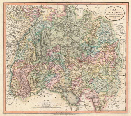
old maps of swabia
maps by john cary
old maps of norway
guillaume sanson
atlante geografico del regno di napoli (1812)
old maps of ariano irpino
géographie générale; physique, politique et économique (1876)
old maps of rivers of france
maps of the islands of greece by marco boschini (1658)
old maps of symi
old maps of northumberland
maps by thomas kitchin
old maps of brabant
1666 in belgium
old maps of brabant
1666 in belgium
maps of the islands of greece by marco boschini (1658)
old maps of the lesser cyclades
701 - 800 of 887
Next page
/ 9


![Carpetaniae partis descr. / [Georgius Hoefnaglius], Joris Hoefnagel, 1584](https://cdn.creazilla.com/illustrations/10000765930/carpetaniae-partis-descr-georgius-hoefnaglius-joris-hoefnagel-1584-sm.jpg)


![Wallia principatus vulgo Wales: Seren[issi]mo Domino Carolo Magnae Britanniae, etc. Principi [signé] Joh. Blaeu, 1673](https://cdn.creazilla.com/illustrations/10001204343/wallia-principatus-vulgo-wales-serenissimo-domino-carolo-magnae-britanniae-etc-principi-sign-joh-blaeu-1673-md.jpg)


![Cerigo / [par Marco Boschini], Marco Boschini, 1651](https://cdn.creazilla.com/illustrations/10000847729/cerigo-par-marco-boschini-marco-boschini-1651-sm.jpg)


![Monte Santo / [by Marco Boschini], Marco Boschini, 1658](https://cdn.creazilla.com/illustrations/10001562665/monte-santo-by-marco-boschini-marco-boschini-1658-sm.webp)


![Isolette [Raclia, Schinussa, etc] / Marco Boschini, 1658](https://cdn.creazilla.com/illustrations/10000518565/isolette-raclia-schinussa-etc-marco-boschini-1658-sm.webp)